AgWise / Remote sensing

remote sensing for information at pixel and administrative levels
Remote sensing is the process of gathering information about the Earth’s surface, waters and atmosphere (also called Earth Observation, EO) via ground-based, airborne and/or satellite platforms. AgWise uses remote sensing to provide crop type probability maps and actual planting dates at pixel and administrative levels.
With its broad coverage and low cost, EO has long been used for crop monitoring at various scales. Unlike crop models, remote sensing-based techniques offer direct measurements of crop vegetation, making it highly effective for tracking actual crop development.
What you get using remote sensing in AgWise
The remote sensing AgWise module runs up to national scale while using a minimum ground data. It is combined to statistical models to provide complementary information to crop models, especially on crop type maps and actual planting date. This information can serve as a basis for yield gap analysis and to better understand farmers adaptations to climate change
Crop type maps
to identify key crop-growing areas, enabling targeted agronomic recommendations like fertilizer advice.
Script available in Github
More
The crop type probability map is generated from MODIS NDVI time series using a machine learning framework. Since most farmers’ fields are smaller than the MODIS resolution, the map does not show field-scale crop classification, but rather indicates areas where a specific crop is likely cultivated during a given season. The map reflects crop presence probabilities rather than definitive field boundaries. Ground data from agronomic experiments typically only provide crop presence, so to map both presence and absence, we use an unsupervised learning approach to create a presence/absence dataset. Five machine learning algorithms (linear, non-linear, tree, boosting ensemble, and bagging ensemble) are calibrated and validated, and the top three are combined to generate the final crop type probability map.
Planting Dates
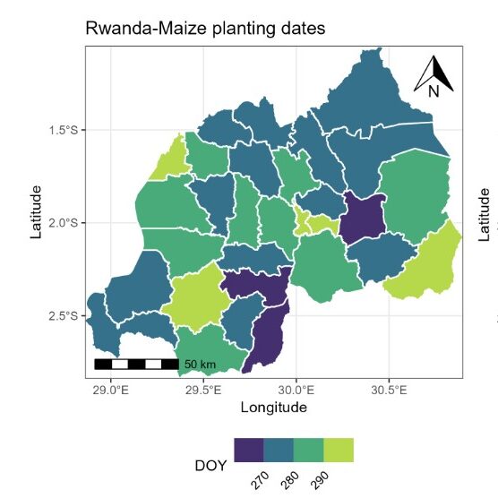
to allow users to compare actual planting dates (from EO) with optimal dates (from crop model).
Script available in Github
More
Since planting dates can vary significantly each year knowing the actual planting is valuable for analyzing yield gaps and tracking farmers’ adaptation to climate change. In AgWise, a method to extract planting and harvesting dates from the NDVI profile by detecting when biomass reaches a specific proportion of the total biomass has been developed. Since a single threshold is unrealistic for all crops and environments, we allow customization of the thresholds for both planting and harvesting dates.
AgWise remote sensing relies on EO and ground data information
MODIS NDVI Data – EO
MODIS VI products (collection 6, combining AQUA and TERRA) provide the longest time series of information on vegetation development at a spatial resolution of 250-m and a 8-days temporal resolution. The MODIS spatial resolution is considered too coarse to provide reliable information for fields under 1ha. However, due to its high temporal resolution, it allows to catch general patterns in crop development at regional scale. A Savitzky-Golay temporal filter algorithm is used for smoothing the time series in order to remove remaining atmospheric noise and provide a time series with an improved quality.Note : MODIS satellites have been decommissioned on December, 2023. An adaptation of the present workflow relying on Sentinel and VIIRS data is scheduled.
Note : MODIS satellites have been decommissioned on December, 2023. An adaptation of the present workflow relying on Sentinel and VIIRS data is scheduled.
The script to automatically download MODIS data is provided in Github and to pre-process the NDVI time series in Github
ESA World Cover – EO
The European Space Agency (ESA) WorldCover 10 m 2020 product is used to mask-out non cropped pixels from our workflow. It provides a global land cover map for 2020 at 10 m resolution based on Sentinel-1 and Sentinel-2 data, including one cropland class. The product is resampled at a spatial resolution of 250-m to match the MODIS spatial resolution.
The script to automatically download ESA World Cover data is available in Github.
Ground data
Actual planting date as observed by farmers are used to calibrate and/or validate planting date estimation.
Field GPS coordinates are used to train and validate crop type model.
All AgWise Earth Observation resources are in GitHub